Director: Dr. Julia Shaw, London. Collaborators: Dr. John Sutcliffe, Reading; Mr. Lindsay Lloyd-Smith, Cambridge; Dr. O.P Misra, Bhopal. Under sanction from the Department of Archaeology, Museums and Archives, Madhya Pradesh, Bhopal.
THE SANCHI DAMS PROJECT
Sanchi, a UNESCO World Heritage site, is a major Buddhist hilltop complex in central India . It is one of India ‘s best preserved and most studied Buddhist sites with a continuous constructional sequence from c. 3rd century BCE to 12th century CE. The establishment of Sanchi is closely tied to the spread of the Mauryan empire and related processes of urbanisation, the latter well-represented by the early historic city-site of Vidisha, 6 km to the north.
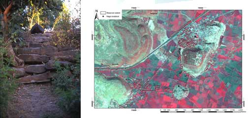
Photo (left): Masonry face of the Sanchi dam
Photo (right): Quickbird satellite imagery of Sanchi area showing location of dams and reconstructed reservoir extents.
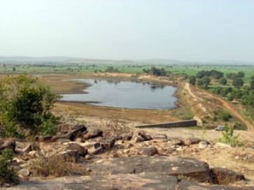
While the formal establishment of Buddhism at Sanchi was connected with state patronage, as attested by the Aśokan inscription there, much building work took place between the late 2nd century BCE and early 1st century CE. Inscriptions show that this work was funded by extensive programmes of collective patronage supported by powerful families and guilds. In the Gupta and post-Gupta periods, the donations of land and villages recorded in inscriptions indicate that the Buddhist sangha was involved in sustainable exchange networks with local agricultural communities. That such links may have existed during earlier periods in central India is suggested by the remains of a 350 m long dam immediately to the south of the hill at Sanchi. This, and a second dam to the west, would have created a reservoir about 3 km2 with a storage capacity of about 3.6 m3 x 106 . Two smaller tanks at Karondih and Dargawan in the shorter valleys to the west appear to have been designed to maintain water levels in the main reservoir as part of an upstream irrigation system.
Similar dams have been found throughout the Sanchi area. All consist of earthen cores with stone facing, mainly on the upstream side, and with heights and lengths varying from 1 to 6 m, and 80 to 1400 m, respectively. The reservoirs have volumes ranging between 0.03 to 4.7 m3 x 106 . While those built on gradually sloping terrain, as at Sanchi, appear to have acted as inundation tanks for upstream irrigation, dams built across deeper valleys as found in the eastern part of the study area were used for downstream irrigation. Some of those in the latter category, such as Devrajpur, show evidence of spillways and sluice gates.
The dams were recorded between 1998 and 2001 during an extensive archaeological survey over c. 750 km2 around Sanchi. The four outlying Buddhist sites documented by Alexander Cunningham in the 19th century were included: Satdhara, Sonari, Morel Khurd and Andher. The survey aimed to situate the monuments within their wider archaeological landscape, relating religious changes during the late centuries BCE to other key processes such as urbanisation, state-formation, and agricultural innovation. The survey resulted in the systematic recording of about 35 Buddhist sites, 145 settlements, 17 irrigation works and numerous sculpture fragments. In recent years, the survey has been developed in several ways including the application of intensive site-mapping, satellite remote-sensing, and the collection of dam and reservoir sediments for geological dating and palaeo-ecological analysis.
Chronological indicators in the form of nāga (serpent) sculptures located on or near some of the embankments have provided a range of terminus ante quem dates between the c. 1st century BCE and 5th century CE. However, recent Optically Stimulated Luminescence (OSL) dating of sediments from selected dam sites suggest that their construction was contemporary with the earliest monuments at Sanchi.
Analysis of surface remains, local present-day hydrology, and ancient pollen sequences, has led to a number of hypotheses regarding the dams’ chronology and function, their associated crop usage, and their relationship to the urban sequence at Vidisha and the history of Buddhism at Sanchi and neighboring sites. These may be summarized as follows: i) the earliest dam construction occurred between c. 3rd and 2nd centuries BCE , following the chronology of the earliest monuments at Sanchi and neighboring Buddhist sites; ii) they were built to provide irrigation, principally for rice, as a response to the increased population levels suggested by the distribution of habitational and Buddhist sites in Vidisha’s hinterland; iii) their position within the wider archaeological landscape warrants their being viewed as part of a cultural package that accompanied the spread of Buddhism, urbanisation and the development of centralised state polities during the late centuries BC; and iv) similarities with inter-site patterns in Sri Lanka, where monastic landlordism is attested from c. 2nd century BC onwards, support the suggestion that the Sanchi dams were underlain by a similar system of exchange between Buddhist monks and local agricultural communities.
The position of nāga sculptures within the wider archaeological complex also sheds important light on theories of religious change, especially those regarding the dynamics between the sangha and ‘local’ agricultural cults. Gupta period accounts of Chinese pilgrims in eastern India show that nāga shrines were propitiated by monks, often within monastic compounds, because of the nāgas’ ability to ensure adequate rainfall and agricultural success. In the Sanchi area, the positioning of nāga shrines on dams conforms with this model, particularly since the sangha appears to have played a role in the management of local irrigation. Nāgaworship was part of Buddhist practice because its effects were in harmony with the sangha’s economic concerns with water-harvesting and agrarian production. This hypothesis, based on the relative configuration of dams, settlements and monasteries in the Sanchi area, as well as similar patterns in western India and Sri Lanka, forms part of an active model of religious change which indicates that monks moved into new areas with a set of motives for local communities to extend their economic support to the monastery.
DOWNLOADS
Water Management, Patronage Networks and Religious Change
Landscape, Water and Religion in Ancient India Bibliography